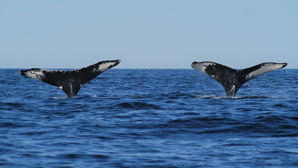
Baleen Whales (Mysticetes)
Baleen whales are the larger whales in the sanctuary; they do not have teeth, but racks of baleen that hang down from the top jaw and are used to filter their food from ocean water. Whale watching was an important reason for the creation of the sanctuary. To better protect these ocean giants, sanctuary researchers have undertaken multiple research and monitoring studies. You can find other whale research projects listed under Acoustics. Also see our Protect section to learn about ways that science and technology have been used to develop whale protection programs, such as the Boston shipping lane shift, ship report cards from the Corporate Responsibility Program and Whale Alert.
Right Whale Research
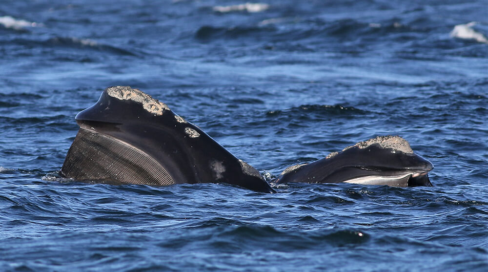
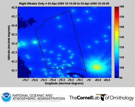
The North Atlantic right whale is one of the most critically endangered species on the planet with only about 350 individuals alive today and, of those, only about 94 breeding females. The sanctuary has participated in tagging projects to study right whale feeding behaviors and is actively involved in acoustics studies to locate the animals and understand how sound is affecting them. Recent research indicates that right whales have lost about 70% of their communication space, meaning that it has become significantly more difficult for the animals to hear each other. The noise of large ships (as illustrated by the moving red and yellow lights on the map) overwhelm the small "firefly" star-like lights that represent right whales. Read more about sanctuary right whale research and the importance in protecting these whales.
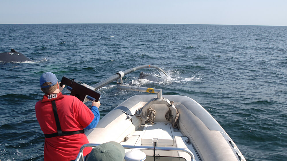
Humpback Whale Tagging
Reducing mortality caused by entanglement in commercial fishing gear and ship strike requires an understanding of how whales use the water column and seafloor relative to human activities.
Ongoing research in the sanctuary, in cooperation with a multi-disciplinary, multi-organization team, uses state-of-the-art multi-sensor tags affixed to the whales with suction cups. The tags function in a similar fashion as human fitness trackers, except on a much grander scale. The non-invasive data-recording units collect information, including heading, pitch, roll, depth, sounds made and heard, and video and imagery (not all tags collect all types of data). Two types of tags are used – DTAGs and CATS. Special data visualization software, GeoZui4D and TrackPlot, use the collected information to provide still and animated images of the underwater behaviors of the tagged animals. These datasets can be coordinated with seafloor maps and Automated Identification System (AIS) records of ship tracks to analyze what factors may be affecting the whales' movements.
Each year researchers learn more about bubble net feeding patterns and bottom feeding techniques (singly, in pairs, and in triads). Bottom feeding has provided proof of "handedness" in humpback whales (more are "righties" than "lefties." Multiple tags have shown cooperative feeding and poaching behaviors. Sound recordings have revealed that male humpbacks sing partial songs in northern feeding grounds and that some whales use unique clicking/buzzing sounds, labeled "megapclicks" or patterned pulses of sound (paired bursts) for nighttime feeding. Tags equipped with video have also shown nursing behavior between a mother and calf and provided insights into the timing of this behavior. Read more about whale nursing. The multi-year project (initiated in 2004) is a collaboration among researchers from the sanctuary, NOAA Fisheries (Greater Atlantic Regional office and Northeast Fisheries Science Center), Woods Hole Oceanographic Institution, University of New Hampshire, Center for Coastal Studies, International Fund for Animal Welfare, UC Santa Cruz, Syracuse University, Stanford University, and many more.
Visit our Research Library page to review the numerous papers that have been generated from this research.
Dtags and CATS
The sanctuary's tagging team employs two types of tags when studying whales – Dtags and CATS tags. The DTag (digital acoustic recording tag) was developed at Woods Hole Oceanographic Institution with a hydrophone to record sounds made and heard by the whale and a suite of sensors that can sample the orientation of the whale in three dimensions, recording pitch, roll, heading, and depth. CATS stands for Customized Animal Tracking Solutions. These tags mainly record movement and video. Data are downloaded from the tags after they detach from the whales and are brought back to the lab. New suction cup technology allows for attachments of up to a few days.
GeoZui4D and TrackPlot
GeoZui4D is a software application developed at the University of New Hampshire's Advanced Visualization Laboratory for interacting with time-varying geospatial data. When combined with data derived from the tags, it creates virtual whales that move in the exact manner of the tagged whales. In addition, GeoZui4D allows the incorporation of other geospatial data, such as ship movements taken from radar or the U. S. Coast Guard's Universal Shipborne Automatic Identification System (AIS) (required for ships >300 gross tons and used voluntarily by others). A feature of the software developed for this project is the ability to provide constant distance readouts from the tagged whale to any vessel in the data field.
Using GeoZui4D, the researchers can view the underwater behavior of tagged whales with vessel movements taken from radar and AIS. In this way, the team can document the reaction of whales relative to the movement of vessels and the sounds whales are hearing.
GeoZui4D can also join humpback whale dive tracks and behavior with data on bottom topography to view and understand whale behavior relative to threats from fishing gear in the water column. For example, studies have shown that humpback whales dive directly to the bottom, turn on their side, and forage in contact with the seabed. These data and visualizations of behavior have been instrumental in formulating plans to reduce the threat of whale entanglement.
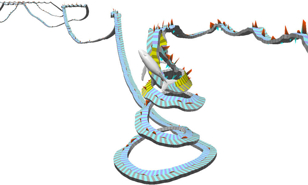
TrackPlot is custom software developed for the project by Colin Ware at UNH's Advanced Visualization Laboratory. The software creates a static image that can provide another form of data visualization in addition to the dynamic real-time, visualizations provided by GeoZUI4D. Several hours of data can be shown in a single image. The ribbon-like band shows the animal's track, with yellow sections indicating side rolls and red and blue polygons depicting fluke strokes. Trackplot also creates useful animations of the whales' tracks.
Studies of Humpback Bubble Feeding
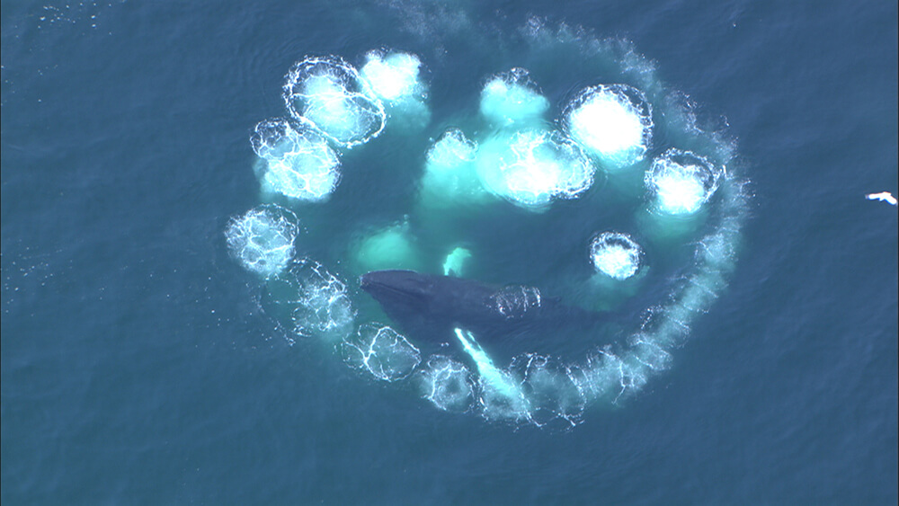
Bubble nets and bubble clouds are distinctive feeding techniques developed by humpback whales to corral schools of small fish. The whales have learned that bubbles released at a particular depth will rise to the surface, and that encircled fish will not penetrate that wall of bubbles. If bubbles are released at lower depths, the bubble will dissipate and the wall will collapse. Humpbacks at Stellwagen Bank, and in the region, have perfected several types of net feeding strategies – the single or double loop and the upward spiral.
As its name implies, the upward spiral is a single, continuous curving movement from depth to the surface. As the bubbles rise along with the whale, the fish retreat to the surface where the whale then takes a massive gulp. The loop method involves a circle of bubbles at depth in which the whale surrounds its prey with bubbles, a trip to the surface to slap the water with its tail – or lobtail – to stun or disorient the fish, and then a quick dive (straight or circling) under the fish for the final capture.
Bottom Feeding and Handedness
Whale tagging has revealed that whales also employ hidden feeding techniques along the seafloor, in addition to the more observable bubble nets and lunges at the sea surface. Illustrated TrackPlots of tag data indicate that humpbacks skim the sediments to force sand lance out of the sand. The whales make repeated rolls, all in the same direction as they move along a path. At times, whales work together in teams of two or three, to trap the schooling fish between them. Scientists have found that the whales sometimes meet "nose-to-nose," as if they are herding their prey.
A recent paper published in Marine Mammal Science explains the findings.
Bottom feeding by humpbacks had long been suspected by researchers due to the appearance of scuff marks on the lower jaws of many whales. Tracking data shows the whales working the seafloor, angling their bodies at about 45 degrees with their bottom jaws scraping the sand. Surprisingly, the whales display individual preferences for which side contacts the bottom, with the majority preferring the a right side, similar to human handedness (about 80%).